Check here for the latest updates on snow, winter weather expected in Sioux Falls this weekend
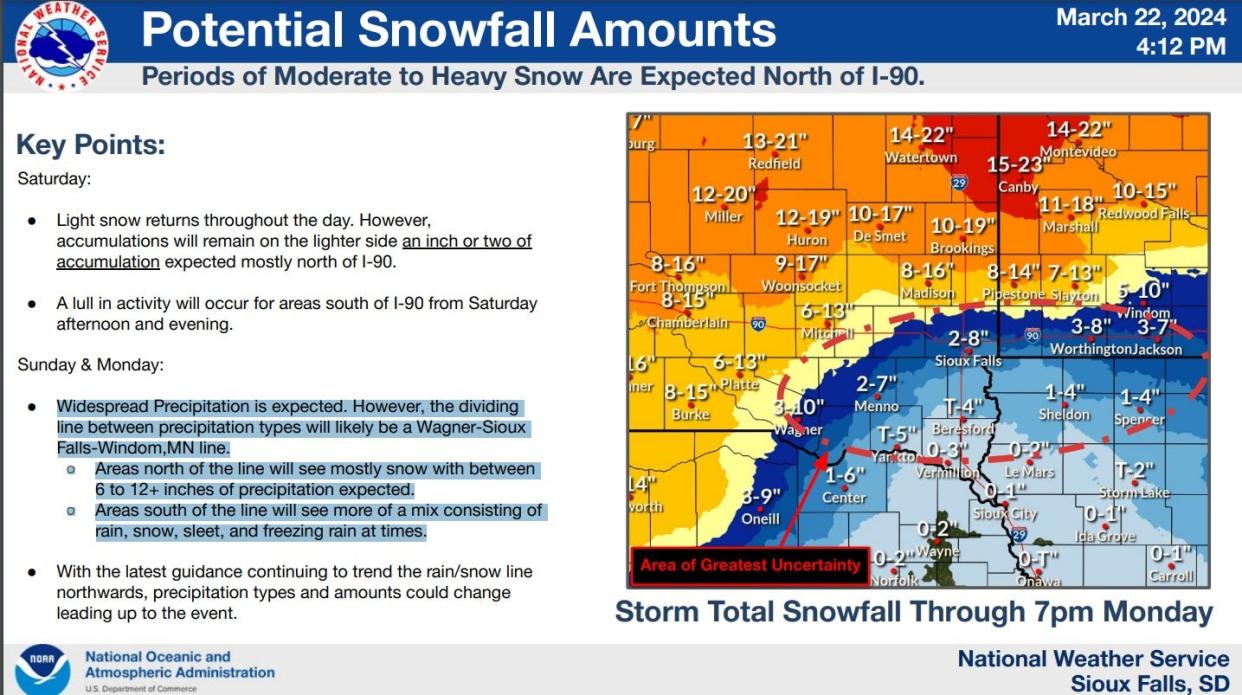
4:45 p.m. Friday: Sioux Falls remains in the area of greatest uncertainty for how much snowfall may arrive as a multi-day winter system moves through from Saturday to Monday, according to the latest update from the National Weather Service.
Light snow will fall Saturday, with 1 to 2 inches possible north of Interstate 90, the NWS stated. Areas north of the Wagner-Sioux Falls-Windom, Minnesota line, could see mostly snow between 6 to 12 inches Sunday and Monday, while areas south of there are expected to see more of a mix of snow, rain and sleet, the NWS stated.
2:30 p.m. Friday: The anticipated winter weather has prompted South Dakota Legislature leadership to reschedule Veto Day, according to a press release from the Legislative Research Council.
A winter storm watch has been issued from Saturday evening to Monday night for central, north central and northeast South Dakota.
"Veto Day is reserved for consideration of gubernatorial vetoes," the release states. "While the Governor did not veto any bills during the 2024 Legislative Session, the South Dakota Senate and the House of Representatives must meet to conclude their business and adjourn sine die, officially ending this year's session."
Earlier story: Look, when Punxsutawney Phil did not see his shadow on Groundhog Day in early February, he clearly didn't have South Dakota weather in mind. He may have called for an early spring, but Sioux Falls and much of South Dakota is bracing to welcome the season with a heap of March snow.
The winter weather kicked off for Sioux Falls Thursday night, with scant amounts of accumulation for the area of around 0.2 inches, the National Weather Service in Sioux Falls reported. But the major threat of snow for the area will come over the weekend, from roughly Saturday morning and going through Sunday.
A few preliminary snowfall reports from last night:
Yankton: 2.0"
Le Mars: 1.5"
Vermillion: 1.2"
Tyndall: 0.7"
Sioux City: 0.2"
Sioux Falls: 0.2"
Any reports from NW IA? Send them our way!— NWS Sioux Falls (@NWSSiouxFalls) March 22, 2024
How much snow are we supposed to get in Sioux Falls?
As of Friday, the total amount of snow Sioux Falls can expect remained up in the air.
The National Weather Service has issued a Hazardous Weather Outlook for northwest Iowa, west central Iowa, southwest Minnesota, northeast Nebraska and southeast South Dakota — an area including Minnehaha County — that calls for light snow on Saturday, wintry mix/freezing rain on Sunday and more snow come Monday.
"As colder air wraps in later Monday into Monday night, precipitation will transition back to snow, with total snowfall accumulations highly dependent on the timing of rain/snow transitions," the National Weather Service's forecast states.
The amount of snow you will see depends greatly on the track of the storm and the timing of its movements. Keep an eye on your local forecast closely over the weekend to track the storm's progress and get a better idea of snowfall totals in your area, because "the difference of one or two degrees could mean the difference between heavy rain, a mix or heavy snow," the NWS said.
Sioux Falls road conditions
Check out traffic cameras here or on the city's official site to monitor road conditions from the safety of your home, or wherever you find yourself, as the storm passes through Sioux Falls. To focus on a specific camera, click the enlarge button at the top right corner of the camera you want to enhance. On mobile, tap the button with your finger.
You can also check the South Dakota DOT's 511 road conditions map which includes National Weather Service alerts, road closures, incidents, obstructions, construction and more.
Sioux Falls weather forecast
Here is the forecast for the weekend from the National Weather Service.
Friday: Mostly cloudy, with a high around 36. Steady wind, with gusts reaching up to 20 mph.
Friday night: Partly cloudy, low around 18, gentle wind.
Saturday: Mostly cloudy, with highs approaching 34. Snow likely in the afternoon between 1 p.m. and 4 p.m. with a 60% chance of precipitation. New snow accumulation of less than a half inch possible. Wind gusts as high as 25 mph.
Saturday night into Sunday: Snow likely after 1 a.m. with patchy, blowing snow after 3 a.m. New snow accumulation of around an inch possible. Windy conditions, around 15 to 20 mph with gusts as high as 30 mph.
Sunday: More patchy, blowing snow expected before 10 a.m., then rain, maybe mixed with snow. Patchy blowing snow before 10 a.m. New snow accumulation of around 2 inches. High temperature of 38. Breezy conditions around 20 to 25 mph, with gusts as high as 40 mph.
Sunday night: Thunder possible, rain and snow showers. Minimal new accumulation, but plenty of wind. Low temperature of around 31 degrees.
Monday: Snow, maybe mixed with rain, with patchy, blowing snow expected in the afternoon. High close to 36.
Monday night: A 50% chance of patchy, blowing snow.
This article originally appeared on Sioux Falls Argus Leader: Sioux Falls weather, snow updates: NWS predicts snow over weekend
