Tropical Storm Bret racing toward Caribbean as forecasters monitor Tropical Depression Four


Tropical Storm Bret - the second named storm of the 2023 Atlantic hurricane season - will continue to take a slightly north-of-west trek and reach the Caribbean prior to the end of the week, AccuWeather meteorologists warn. There is also a system right on Bret's heels that was designated by the National Hurricane Center as Tropical Depression Four as of 8 a.m. Thursday.
Tropical Storm Bret has a limited amount of time to strengthen, AccuWeather Chief On-Air Meteorologist Bernie Rayno said.
 |
"As Bret moves into the eastern Caribbean later this week, the storm is forecast to encounter increasing wind shear. This wind shear would prevent further intensification and Bret will begin to lose organization Friday and into the weekend," explained AccuWeather Meteorologist Alex DaSilva.
Wind shear, or disruptive winds, is the change in direction and increases in the speed of breezes across the surface of the Earth and at different altitudes in the atmosphere. When wind shear is strong, it can rip apart established tropical systems or prevent tropical systems from forming in the first place - with few exceptions.
 |
"This same zone also marks a pocket where there is some moisture available in the atmosphere," Rayno said, adding that there is some dry air just to the north that could be drawn in and handcuff Bret's ability to strengthen to some extent.
As of 11 a.m. EDT Thursday, Bret was located about 130 miles east-northeast of the island of Barbados and was moving at a swift pace of 14 mph. The storm's maximum sustained winds were 70 mph.
A tropical storm watch has been issued for the islands of Barbados, St. Vincent and the Grenadines. A tropical storm warning has been issued for Dominica, Saint Lucia and Martinique. An Air Force Hurricane Hunter aircraft investigated the storm Wednesday night.
After the Air Force Hurricane Hunter found 70-mph winds, a hurricane watch was also issued for Saint Lucia. Hurricane-force winds begin at 74 mph. However, AccuWeather meteorologists are not expecting Bret to strengthen into a hurricane.
Sea-surface temperatures are well above the historical average for mid- to late June over the Atlantic and in much of the Caribbean. Waters generally range from 82-85 F and the 80-degree mark is the approximate low threshold for tropical development. However, there have been some cases in the past when a tropical system formed with water temperatures in the upper 70s.
As this system travels farther west, it will encounter hot air near the Caribbean which could give the storm a boost in terms of strengthening. However, that air is also dry, and there is more wind shear in this region. There is also the factor of the islands to the north and South America to the south which could be an additional source of dry air and friction.
 |
"There is not high confidence that Bret will maintain its strength as it travels across the Caribbean because of the conditions in the area," Rayno said. However, due to rain and wind impacts, Bret is a 1 on the AccuWeather RealImpact™ scale for Hurricanes in the Caribbean.
Residents and visitors in the Windwards and Leewards, which make up the easternmost islands in the Caribbean, will notice a quick decline in weather conditions from Thursday to early Friday. Building seas and surf, increasing winds and more frequent tropical downpours and gusty thunderstorms are expected.
At this time, gusts with a tropical storm force of 40-60 mph are likely to spread through the Windward and Leeward islands. Hurricane-force gusts are possible in portions of the Leewards and Windwards near the storm center, with an AccuWeather Local StormMax™ gust of 100 mph possible. Any wind gusts above 40 mph are capable of breaking tree limbs, while gusts approaching hurricane force (74 mph) and above can lead to roof damage, downed trees and power outages.
 |
How severe conditions become as Bret moves westward will depend on the track, size and strength of the system itself. A system that travels close to the islands will have much more intense wind and rain as well as a greater risk of damage and flooding than a minimal tropical storm that travels about 100 miles away. This will especially be a key for the progressively larger land areas across the northern Caribbean from the United States and British Virgin Islands to Puerto Rico and Hispaniola over the course of this weekend and into next week.
"There is some potential that even if the system remains weak, it could allow thunderstorms to erupt well away from the center, especially over the higher mountains on Puerto Rico and Hispaniola," AccuWeather Lead Long-Range Meteorologist Paul Pastelok said. That is a challenge to gauge until the storms erupt, but they could still unleash heavy rainfall and flash flooding. This condition can occur as the atmospheric pressure lowers in the region, which makes it easier for thunderstorms to erupt.
 |
There is the likelihood of a broad area of 1-2 inches of rain, which may not cause significant problems. However, where more moisture is squeezed out in mountainous terrain or where a direct strike occurs, rainfall of 2-4 inches is likely. An AccuWeather Local StormMax™ of 10 inches is possible.
The islands of the northern Caribbean to as far west as Hispaniola could use some non-flooding rainfall after weeks of heat and dry conditions. Close to Cuba and much of the central and northern Bahamas, rain is not needed due to a week or more of frequent downpours recently.
Several hundred miles to the southeast of Bret over the central Atlantic, another batch of thunderstorms had some very weak spin as indicated by satellite observations early Thursday. These thunderstorms gained enough organization to be designated as Tropical Depression Four early Thursday morning. If the system strengthens beyond that of a tropical depression, the next name on the list of Atlantic tropical storms for 2023 is Cindy.
 |
A tropical depression has a defined circulation with sustained winds of 35-38 mph. A tropical storm has a well-defined circulation with sustained winds of 39-73 mph. The National Hurricane Center makes the official call on whether or not a tropical system is a depression, storm or hurricane.
AccuWeather, on occasion, will dub a system a tropical rainstorm to raise public awareness as soon as possible, especially if such a system has the potential to bring impacts to lives, property and business interests. AccuWeather may also continue to refer to a prior named system if significant impacts will continue for the same reasons.
Earlier in June, well prior to the formation of Tropical Storm Bret, AccuWeather meteorologists raised awareness of an unusually strong tropical wave pattern from the Indian Ocean and Africa, where the waves originate, to the Atlantic Ocean. Historically, the tropical wave season, also known as the Cabo Verde season for the islands just off the coast of Africa, does not ramp up until mid- to late August and continues through September.
 |
This Atlantic tropical season is already ahead of the historical average in terms of named storms. Typically, the first tropical storm does not form until June 20. Bret follows Arlene, which kickstarted the season on June 2 when it developed in the Gulf of Mexico. In May, the NHC revealed that a subtropical storm formed off the coast of the Northeast in January. Forecasters made this determination based on a reanalysis of previous weather patterns.
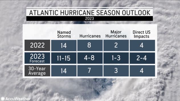
AccuWeather's tropical meteorologists, led by Hurricane Expert Dan Kottlowski, anticipate a near-average season for 2023.
Want next-level safety, ad-free? Unlock advanced, hyperlocal severe weather alerts when you subscribe to Premium+ on the AccuWeather app. AccuWeather Alerts™ are prompted by our expert meteorologists who monitor and analyze dangerous weather risks 24/7 to keep you and your family safer.
