Beaufort County ‘out of the danger zone’ as Hurricane Ian made landfall in South Carolina
As Ian made landfall just south of Georgetown at 2:05 p.m. Friday as a Category 1 hurricane, Beaufort County had largely dodged the earlier predicted worst-case scenario.
The National Weather Service dialed down rainfall amounts, storm surge height and wind speed for the county Friday morning. Ian’s greatest effects were expected to unfold around high tide, which the National Oceanic and Atmospheric Administration gauged was nearly 9 feet in Beaufort a little before 1 p.m. Friday.
Storm surge, which had decreased from previous forecasts, was still considered life-threatening and had the potential to reach between 2-4 feet, according to the NWS. Alongside that, Beaufort County was predicted to experience about 3-4 inches of rainfall by the time Ian’s impact dwindles, likely sometime Saturday.
During an NWS briefing Friday morning, Meteorologist Ron Morales explained that because of Ian’s eastward progression, the track lowered impacts and caused the coastal flooding threat to be “much, much lower.” Overnight Thursday, winds stayed more northerly and now are moving north-northwest, which is holding tide levels down, he said.
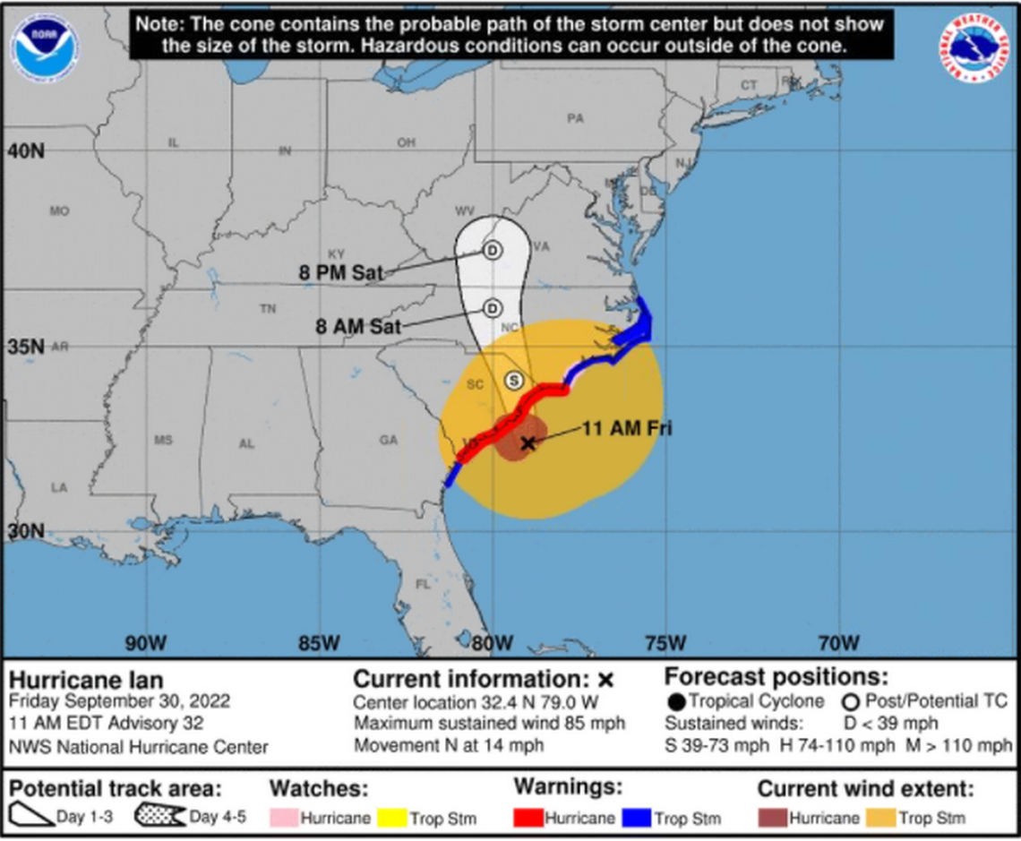
For areas south of the Isle of Palms, which includes Beaufort County, the threat of high storm surge, up to 4 feet, was a “conservative” measure, Morales said. Hilton Head Island and Beaufort may see some tropical storm-force winds and the potential for moderate flooding throughout the afternoon, but Morales noted the greatest threats from Ian were over Atlantic waters and around the Charleston Tri-County area.
“Improving conditions, really, for all hazards is expected later this afternoon,” Morales said, adding that he anticipated warnings would be lifted later Friday.
Wind and flooding still a concern
Early Friday morning, a 45 mph wind gust was recorded at the Hilton Head Island Airport and later, a buoy nearby Fripp Island clocked a peak wind speed of 56 mph. According to the NWS, tropical storm-force winds — between 39 and 73 mph — are possible to whip through Beaufort County.
Before mid-afternoon, what was considered to be the worst of Ian’s wrath in the Lowcountry, the county was seemingly spared from the expected flooding and most residents had heeded Sheriff P.J. Tanner’s Thursday plea to stay home.
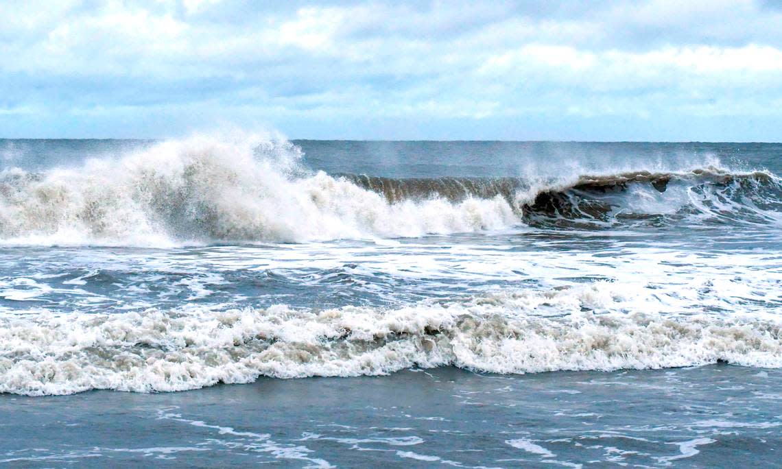
In Beaufort, Bay Street, which is usually bustling with cars and commotion, was pin-drop quiet except for the sounds of wind beating through Palmetto trees. Hilton Head Island’s Coligny beach was equally deserted, as waves churned onto shore under an overcast sky. Nearly 3,000 residents were without power mid-morning Friday.

About 10 a.m. Friday, the Beaufort County Sheriff’s Office said although “it appears we are out of the danger zone, flooding and wind damage is still a concern.” Before noon, wind speed was about 28 mph with 44 mph gusts.
On Hilton Head Island, the streets were mostly devoid of traffic and the beaches were empty, except for a few surfers who braved the waters around noon Friday.
Mayor John McCann said there was still potential for damaging surf and high winds and that people should heed caution, but added, “God has been good to us this time.”
The region was fortunate than Ian’s track changed, but nonetheless the storm was a good drill to test hurricane plans, said Beaufort Mayor Stephen Murray. In a Friday call with Beaufort County emergency management officials and local leaders, Murray said, it was reported that countywide, power outages were limited and about 10 trees were reported down.
On Hilton Head Island, its fire rescue team responded to six downed trees with no injuries or significant damages, according to a town news release Friday afternoon. At that time, there were no other storm-related calls for service and an assessment of the island’s beaches had not been completed, due to the threat of storm surge.
Around noon, rain in Bluffton and Beaufort had let up and winds weren’t as blustery. During a 1 p.m. press conference, Gov. Henry McMaster said that even where there’s not much water, South Carolina residents need to be cautious about winds.
“(South Carolina’s) not out of the woods,” McMaster said, adding that Ian’s landfall is “still coming.”
South Carolina officials said to expect more damage to trees and power lines, and the potential for more power outages, into Friday evening. Nanette Edwards, the Office of Regulatory Staff’s executive director, said during the press conference that when wind speeds drop below 30 mph, crews will be able to safely restore power.
According to NWS, the county remains under five alerts as of Friday afternoon:
High surf advisory until 8 a.m. Saturday
Rip current advisory until 8 p.m. Friday
Flood watch until midnight Saturday
Hurricane warning
Storm surge warning
Island Packet reporter Karl Puckett contributed to this report.
