Atlantic hurricane season’s dry spell could end soon. Why has it been so quiet?
With a number of systems whirling in the Atlantic, including one that could become a named storm in the next few days, the tropics are definitely heating up.
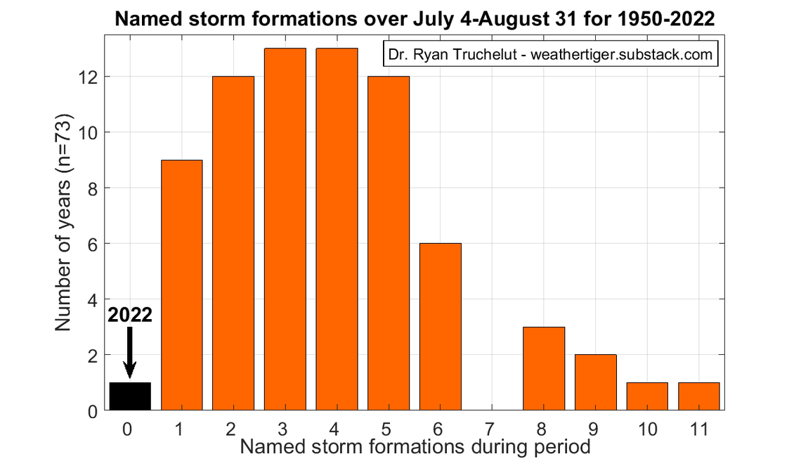
But hurricane season 2022 may also go down in history for the opposite reason: Unnatural quiet. If a storm doesn’t earn a name by the weekend, it could mark a record — two whole months without a named storm forming in the Atlantic.
Despite NOAA’s initial prediction of an above-average season (and a mid-season follow-up insisting on it), it’s been an unusually quiet summer to date.
What’s ahead for hurricane season? NOAA has an update and a prediction on storms
A low-key early summer isn’t rare. Historically, only 10% of the entire season’s storm activity happens before late August, with a meteorological peak in mid-September. But 2022 has had the least active start to a hurricane season in more than 30 years. The Atlantic usually sees about two hurricanes by this time. This year, we’ve had none.
Whether August will pass without another named storm will be a close call.
One system out there has a high chance of formation this week — 80%, as of the National Hurricane Center’s Monday morning update — but it’s too soon to know if what would be called Danielle will pose a threat to Florida or elsewhere. The latest computer models suggest the weather system could curve north, missing the Bahamas and staying far east of Florida’s coast but it’s far too early to tell.
Since the season officially kicked off on June 1, there have been just three named storms, with the latest in early July. The average activity for the last 30 years suggests we should have seen eight by now, tweeted Steve Bowen, a meteorologist with financial firm Aon.
“The 2022 Atlantic Hurricane Season continues to defy logic given time of year and conditions in place,” he wrote.
For storm watchers, two factors almost always spell an active hurricane season: warm ocean waters, which provide moisture as fuel for powerful storms, and a global weather phenomenon called La Niña, which is linked to a more active Atlantic season.
This season has both.
Sunday marked the highest sea surface temperature on record for the North Atlantic, according to the University of Maine’s calculations. And NOAA data shows this is the strongest second year of a La Niña on record, tweeted Kieran Bhatia, vice president of reinsurance firm Guy Carpenter.
‘But so far, 2+2 = 0 and not 4 for Atlantic TC activity,” Bhatia wrote.
Meteorologists say this season’s silence is likely due to a mid-level layer of unusually dry air in the Atlantic, as well as a steady stream of Saharan dust blowing off the coast of Africa. Hurricanes need lots of warm, moist air to power up. Dry air evaporates that moisture, cooling down the storm’s core and limiting its ability to grow tall and strong. Dust does something similar.
“You can’t bake a cake with two out of three ingredients. We’re missing midlevel moisture and that’s great, that’s what’s keeping things in check as we head into the peak,” said Ryan Truchelut, chief meteorologist of private forecast firm Weather Tiger.
He said another factor keeping July and August quiet could have been the very active Pacific storm season. Truchelut said the two regions have something of an inverse relationship, and the “exhaust” from the dissipated Pacific storms made the Caribbean and Gulf of Mexico less friendly for storm formation.
“That, I think, kept a lid on some of the activity that could have formed closer to home in July and early August, he said.
Another point in favor of a quiet season ahead? The historical record. Past storm seasons suggest it may be tough to achieve NOAA’s above-average season prediction at this point.
Kim Wood, an associate professor of meteorology at Mississippi State University, tweeted that since the satellite era started in 1966, only 1967 had this low level of hurricane activity by August 28 and still reached above-average activity.
But despite the forces keeping storms in check, for now, Wood cautioned that a quiet start to the season doesn’t always guarantee a quiet finish. Ocean conditions are almost picture perfect for more storms to form, and there are at least six more weeks of peak season ahead.
“We would need a whole lot of activity in a short period of time to reach the thresholds of an active season, but that doesn’t mean it’s impossible,” Wood said. “If the dry air stops coming into the main development region and these waves keep coming off Africa in a regular fashion, there could be many storms in September.”
