Rounds of rain, snow to slow travel in Western US into next week

By Alex Sosnowski for Accuweather.com
A large storm is poised to roll into the West with rain, snow and travel disruptions during the second week of November.
The new storm follows the first widespread mountain snow of the season in the West, with totals of 1 to 2 feet of snow on part of the Sierra Nevada, Colorado Rockies and portions of northern Nevada, during the first week of November.
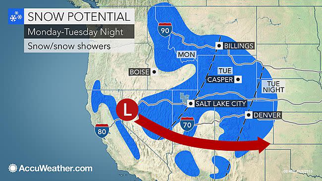
Motorists heading over the passes from Washington to northern California, Montana and Colorado may run into accumulating snow with a slow and slippery drive with the new storm. Snow is likely to reach the metro areas of Salt Lake City and Denver and could make roads slushy.
According to AccuWeather Senior Meteorologist Ken Clark, "There is more good news on the way for part of the drought-stricken West starting this weekend and continuing into next week."
The storm will continue to build the snowpack in the high country and soak the soil at lower elevations of the West.
WATCH: Snow blankets Flagstaff, Arizona:

The Pacific storm will first send a moderate amount of rain southward along the coasts of Washington, Oregon and northern California through Saturday. A soaking is in store for Seattle, Portland, Oregon, and Crescent City, California.
About an inch of rain will fall along the Washington and Oregon coasts near sea level with locally higher amounts. Enough rain could fall with low visibility to cause flight delays in Seattle this weekend.
RELATED:
PHOTOS: Snow Blankets Western US in First Widespread Taste of Winter
Sierra Nevada's Lowest Snowpack in 500 Years Provides Range of Benefits, Hardships to Hikers
WATCH: Lightning Radiates Night Sky of California During Recent Storm
Into Monday, the storm will strengthen and move southward along the Pacific coast. Rounds of rain will ramp up and expand inland, while snow levels will lower from north to south over the Cascades.
The high country in the Cascades could pick up 6-12 inches of snow from the storm. Snow is likely to reach down to the passes in Washington and Oregon. Slushy areas may develop along Interstate 90 through Snoqualmie Pass.
The most likely time for drenching rain and travel delays in San Francisco and Sacramento, California, is on Monday. Gusty winds may also affect the coast of northern California during Monday.
The heaviest snow will focus on central and northern Sierra Nevada on Monday into Tuesday. Snowfall in the high country in this area could exceed a foot. Accumulating snow is likely to extend to Donner Pass.
The storm will turn inland over the West Monday into Wednesday.
"How far south, how much snow falls and how low snow levels get over the Sierra Nevada, Great Basin and Rockies will depend on the track of the storm and how much moisture is available," Clark said.
"There is the potential for some locations to be hit with similar or perhaps greater snowfall," Clark said.
More snow will fall farther north across the interior West next week, when compared to this week's storm. In addition to parts of I-80 in Nevada and Wyoming and I-70 in Colorado, the storm next week is likely to bring significant wintry impacts and potential travel disruptions along I-90 from the Bitterroot Range to the Black Hills. Other ranges that could receive heavy snow include the Tetons, Bighorns and Laramie mountains.
Salt Lake City will get another chance at snow by Tuesday.
%shareLinks-quote="A soaking is in store for Seattle, Portland, Oregon, and Crescent City, California." type="spreadWord"%
There is a chance that enough snow will fall to cover roads and make for slippery travel in the Denver metro area Tuesday night into Wednesday, Veterans Day. There is a chance of a major snowstorm in the Colorado Rockies, including the Denver area and along much of I-25 in Colorado.
"Some snow could again dip as far south as Flagstaff, Arizona, and portions of I-40 eastward to northwestern New Mexico," Clark said. "However, the snow in this area may not be as heavy as the last storm."
For cities such as Los Angeles, Las Vegas and Phoenix, it is a bit too early to say for sure whether the storm will bring significant rain or not next week. However, parts of the metro areas could receive a shower.
Storms will continue to roll onto the upper part of the Pacific coast next week. Storms packing wind, rain and snow may arrive around Wednesday and Friday.
