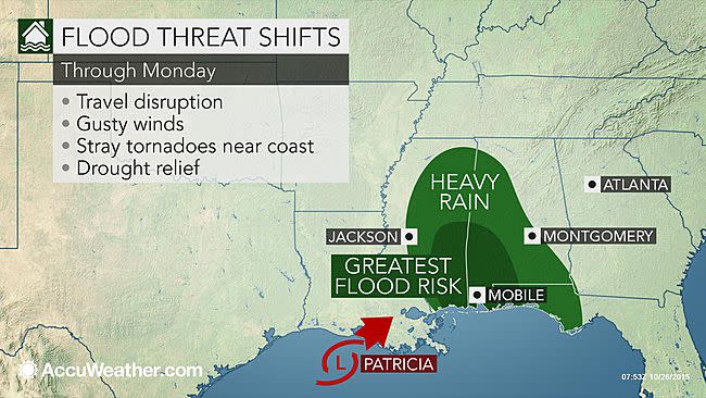
Patricia to spread flood threat from Mississippi to the Florida Panhandle on Monday

By KRISTINA PYDYNOWSKI for AccuWeather
While Texas and Louisiana bore the brunt of the major flooding Friday into Sunday as moisture from once-Hurricane Patricia arrived, the flood danger will continue to shift eastward across the Deep South through Monday.
Heavy rain will continue to spread from Mississippi to Alabama and the Florida Panhandle through Monday, accompanied by the threat for flooding.
READ MORE: Canadian whale-watching boat sinks, killing 5 with 1 missing
%shareLinks-quote="Gulfport, Mississippi; Mobile, Alabama; and Pensacola, Florida, will be at risk for flooding rain through Monday." type="spreadWord"%
In addition to the heavy rain, isolated tornadoes threaten to spin up at the coast. A woman sustained injuries on Sunday outside of New Orleans as a tornado damaged her mobile home.
The greatest concern for widespread and life-threatening flooding will exist from southeast Mississippi to the Florida Panhandle. Rainfall totals will generally be on the order of 3-6 inches with localized higher amounts.
Aside from along the coast of Alabama and the Florida Panhandle, flooding will be on a more localized level across the rest of the Deep South on Monday. However, it only takes one flooding incident to put lives and property in danger.
Areas that first experience flash flooding will be low water crossings, small streams, secondary roads and urban areas that drain poorly. Flooding will only worsen as the rain intensifies and persists over a given area.
Excessive rainfall will cause streams and small rivers to turn into raging waterways and overflow their banks, inundating neighboring roads and homes. The flood waters could lead to the closure of more major highways and interstates, while also affecting rail travel.
RELATED:
Interactive South Central US Radar
Flood-Related Watches, Warnings
POLL: Would You Support a Flood-Related 'Stupid Motorist Law' in Your State?
The flooding could once again become severe enough in some communities to force evacuations and cause some roads and bridges to be washed away.
Check out hurricane incidents by state:
As was seen in Corsicana, Texas, Friday, flood waters could rise faster than officials can close roads with rainfall rates reaching 1-3 inches per hour in the heaviest downpours. Motorists in this situation could become stranded and be put in harm's way.
%shareLinks-quote="Corsicana was one of the hardest-hit areas, where rainfall totals exceeded 20 inches." type="spreadWord"%
Never attempt to drive through a flooded roadway. Doing so puts not only you and your occupants at risk for drowning, but also your would-be rescuers.
READ MORE: Most vitamins are totally useless -- here are the ones you should actually take
The current could be strong enough to sweep your vehicle downstream into deeper water as 1-2 feet of water is enough to cause most vehicles to lose control. The water level may rapidly rise across roadways, which may be compromised below the surface.
Parents are urged to keep their kids away from stream banks and culverts. The bank of a stream can give way, and rapidly rising water can sweep away onlookers.
Even if flooding does not ensue, travel disruptions are likely due to poor visibility and heavy rainfall. Lengthy airline delays are possible. Motorists will need to reduce their speed to lower the risk of hydroplaning.
Patricia and moisture from the Gulf of Mexico are to blame for the heavy rain and flood incidents.
See photos of damage in Mexico caused by Hurricane Patricia:
Patricia rapidly intensified into the strongest hurricane on record early Friday morning and slammed into southwestern Mexico Friday evening with catastrophic force.
The mountainous terrain of Mexico caused Patricia to weaken rapidly, but reached the northwestern Gulf of Mexico as a tropical rainstorm.
Winds created by the storm system will reach gale force at times along the Alabama and Florida Panhandle coast on Monday.
The winds blowing onshore could lead to coastal flooding, especially during high tide.
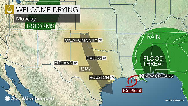
Drier air will gradually sweep in from west to east across Texas and Louisiana during the first part of the new week. At the same time, tropical moisture will be spreading to the Midwest and Eastern U.S., leading to the most significant rainfall in a few weeks for many of those communities.
Even as the rain comes to an end and smaller streams and rivers return to their banks, larger rivers may rise as the flood waters drain downstream. This includes the Trinity River in eastern Texas.
There is a long-term benefit to the torrential rain inundating the South Central states--ending the unusually dry spell that resulted in extreme to exceptional drought conditions developing across nearly a quarter of the area from Texas and Oklahoma to Mississippi.
Content contributed by AccuWeather Meteorologists Alex Sosnowski and Brett Rathbun.
PHOTOS: Hurricane Patricia's path across the South
More from AOL.com:
Guatemalan comedian wins presidency in landslide
Indonesia arrests Indian man wanted in murders of 20 women
Bill Clinton gets his own email scandal
