It's been 10 years since a destructive derecho tore through the DC area


June 29, 2012, is a difficult day for those in and around Washington, D.C., to forget. On that day, an intense line of extremely gusty thunderstorms taught millions of people a new word: derecho.
The 2012 derecho is, without a doubt, one of the worst storms in the district's history, but the storm didn't just impact the D.C. area -- it was blamed for dozens of fatalities across multiple states. The storm's origins lie in derecho-prone Iowa, with the storm leaving significant wind damage along an 800-mile path from the Hawkeye State to the Delmarva Peninsula.
 |
The derecho kept its distinctive bow echo shape - which develops on radar when strong winds reach the surface and spread horizontally - from Indiana all the way to the Atlantic Ocean. |
The storms that would become the derecho began as a mostly subsevere complex in Iowa and northern Illinois, leaving scattered damage in Chicago's southern suburbs around noon Central Time. Soon after, the first of several severe thunderstorm watches was issued.
The storm gained steam and strength as it moved through Indiana, taking on the distinctive bow echo shape - a curved shape that develops on radar in the gustiest of storms, including derechos. A derecho is not just a strong windstorm; there are strict criteria that the National Weather Service's Storm Prediction Center (SPC) references to decide whether a storm complex qualifies as a derecho.
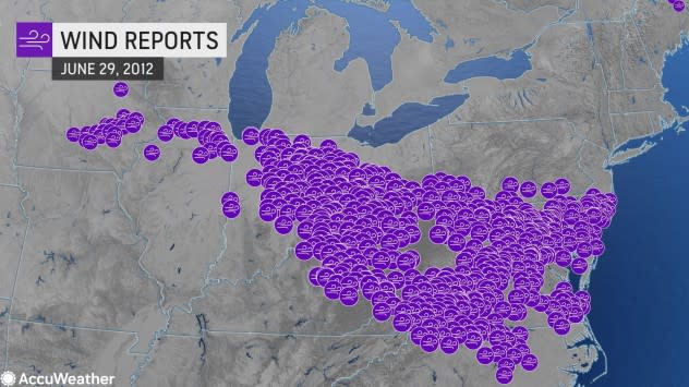
 |
All of the wind damage reports from the 2012 derecho as it moved from central Iowa all the way to the Atlantic Ocean. |
"A derecho wind damage swath must extend either continuously or intermittently more than 400 miles with a width of at least 60 miles," the SPC wrote on its website, explaining the newly updated criteria used to decide if a storm is a derecho. In past years, a storm complex could be called a derecho if it caused wind gusts of 58 mph or greater along a substantial portion of its path as well as straight-line wind damage reports along a roughly 240-mile path or greater.
As what would be the 2012 derecho roared across the Ohio Valley, it became clear that the storm was likely to maintain derecho strength as it continued to march through populated areas. A wind gust of 91 mph was recorded in Fort Wayne, Indiana, the strongest wind gust in the storm's history.
The storm continued pushing through Indiana, Ohio, northern Kentucky and West Virginia, leaving behind destruction and causing the SPC to issue a downstream severe thunderstorm watch for much of Virginia and Maryland and all of the nation's capital.
In the D.C. area, conditions were primed to allow the derecho to maintain its strength, even as the storm moved into the area in the overnight hours, when the environment is typically less primed for intense thunderstorms. Temperatures had just hit a record 104 degrees, providing lots of energy in the atmosphere to fuel an intense wave of storms.
As the sun set in and around the nation's capital, meteorologists were ready for the intense windstorm, and a severe thunderstorm watch was issued around 6:30 p.m., hours ahead of the storm's arrival around 11 p.m. Still, the fury of the winds, which gusted at more than 80 mph, surprised many in the region, as storms were not forecast by most until just hours before they tore through the region.
 |
A radar image of the derecho as it pushed through Virginia, Maryland, Washington D.C., and Delaware. |
By 11 p.m., the storm had already pushed through the western D.C. suburbs, leaving hundreds of thousands of people in the dark.
"It was remarkable looking to the northwest and seeing blue flashes light up the sky as transformer after transformer blew as the line was pushing through," Tim Felice, a longtime resident of Arlington, Virginia, told AccuWeather.
AccuWeather Digital Journalist John Murphy was living in Leesburg, Virginia, at the time and vividly remembered what he realized would be a historical derecho as it blasted into the area.
"The brightness from the lightning gave visible glances at this huge shelf cloud in the distance, which was the leading edge of the derecho. I will never forget the loud howl of the wind when the derecho first impacted my house in Leesburg," Murphy said.
Ghastly wind gusts woke many people up from their sleep as branches and trees fell across the area. The lightning was intense too, with the typically black sky looking more like a strobe light. In the aftermath of the late-night walloping, the sounds of thunder and lightning were replaced by sirens but an otherwise eerie silence, with power outages grinding the region to a halt.
"When [the winds hit] the trees started moving in ways that I'd never seen them move before. They were bending like flexible dancers, and my eyes were getting covered in dust," George Matovu, an atmospheric science major at George Mason University who lived in Herndon, Virginia, during the storm, told AccuWeather. "About 90 seconds to two minutes into the probably 50- to 60-mile per hour wind gusts, the power went out and I went inside."
 |
Tyler Taylor, 14, of Falls Church, Virginia, walks across a large downed tree in his neighborhood on Sunday, July 1, 2012. A severe storm late Friday knocked out power to approximately one million residents, traffic signals and businesses in the region. (AP Photo/Cliff Owen) |
The storm knocked out power to more than 1 million people in and around D.C. and even took down 911 services in parts of the region. In total, more than 300 damage reports were recorded in and around the nation's capital, according to WJLA.
All told, the derecho killed dozens -- some directly from falling trees and others from the intense heat in the aftermath of the storm, and the total damage from the long-tracked storms approached $3 billion. More than 4.2 million people across the path of the derecho lost power, setting the stage for a second disaster: a major heat wave while millions had no air conditioning.
With millions out of power and extreme heat setting in, power crews from around the country were sent to the Washington, D.C., area, and states of emergency were declared in Virginia, Maryland, Washington, D.C., Ohio and West Virginia.
Overwhelmed local utility companies were unable to restore power by themselves. Crews were dispatched to the area from as far as Florida and Texas, according to reporting from The Washington Post.
As the cleanup continued, it was hardly unheard of for it to take more than a week for people to get their power back online. Just 6% of households and businesses in the D.C. area had their power restored after the first day of outages, according to a report from the U.S. Department of Energy.
For those unlucky enough to remain without power for days, the heat made conditions unbearable. From June 28 through July 8, the lowest high temperature in Washington, D.C., was 95 degrees, with temperatures crossing the century mark a remarkable five times, including a high temperature of 105 degrees on July 7.
In West Virginia, where it was also brutally hot and wind damage was widespread, only 51% of residents had their power restored after four days, leading the National Guard to step in and distribute supplies.
Even the utility workers were treated for heat-related injuries, with five utility workers with AEP Ohio suffering from heat exhaustion with temperatures rising near the century mark.
Since the 2012 derecho, there has not been a storm quite as widespread and strong in the Washington, D.C., area. Numerous other strong derechos have struck the United States, however, including a derecho in December 2021 that produced over 120 tornados and a destructive derecho in Iowa in August 2020 in which wind speeds reached over 110 mph.
Additional reporting by John Murphy.
Want next-level safety, ad-free? Unlock advanced, hyperlocal severe weather alerts when you subscribe to Premium+ on the AccuWeather app. AccuWeather Alerts™ are prompted by our expert meteorologists who monitor and analyze dangerous weather risks 24/7 to keep you and your family safer.
