Heaviest snow in storm train to hit New York State to New England by Monday

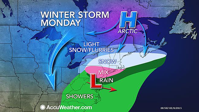
The last in a series of storms bringing snow to part of the Northeast will bring the heaviest snow, most widespread ice, and greatest disruptions to travel and daily activities through Monday.
The caboose in the train of storms will end up being the strongest and will bring the heaviest amount of snow by early this week.
The steadiest snow from into Monday night will fall from New York state to New England. A general 6-12 inches of snow is forecast to fall in this swath, with locally higher amounts, especially around Boston and across the Berkshires.
The swath from Boston, northward to Portland, Maine, westward to Concord, New Hampshire; Worcester, Massachusetts; Rutland, Vermont, and Albany, New York, will likely be within the zone that receives the greatest amount of snow from the early week storm and cumulative amount of snow forward from Saturday.
Significant snow will fall on the zone from Providence, Rhode Island, to Hartford, Connecticut, and Poughkeepsie, New York.

Crews and property owners already struggling with up to several feet of snow on the ground and on some roofs will need to prepare and make room for additional snow.
Up to a few inches of snow can reach as far south as northern Pennsylvania, northern New Jersey, the lower Hudson Valley of New York and southern Connecticut.
RELATED:
AccuWeather Winter Weather Center
Check AccuWeather.com MinuteCast® for Your Location
Polar Plunge to Deliver Coldest Air This Winter to Northeast
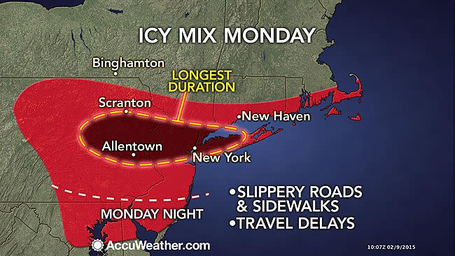
Enough snow, sleet and freezing rain can fall to make roads slippery around New York City and Philadelphia, especially where the precipitation occurs during the early morning and evening hours.
"For much of the New York City area, the concern is more about ice than snow. While there may only be an inch or two of snow in many places, a mix of sleet and freezing rain can make driving and walking very treacherous," warned AccuWeather.com Meteorologist Brian Thompson.
People heading home from their weekend trips may encounter delays, including those partaking in the excellent skiing conditions the onslaught of storms has produced.
The worst of the freezing rain will occur into Monday, resulting in treacherous road conditions for the Monday morning commute.
Airline and ground travel delays due to snow or some sort of wintry mix are likely from Boston, southward to New York City, and westward to Buffalo, Cleveland, Toronto and Detroit on Monday.
The worst travel conditions will be along the New York Thruway and Southern Tier Expressway, the Massachusetts Turnpike, Interstate 84, I-88, I-91, I-93, I-95 from north of New York City to Maine and I-81 in northern Pennsylvania and New York state.
Precipitation will mainly be the form of rain around Baltimore and Washington D.C.
"There will be a huge difference Monday between a windblown snow in Boston with temperatures in the 20s and Washington D.C., where it will be in the 50s with some rain," said Thompson.
The bulk of the snow will exit the Northeast Monday night, but some snow will linger in part of eastern New England and the Appalachians into Tuesday.
Baltimore and Washington D.C. could still see a brief period of icy conditions as the precipitation comes to an end Monday night before dry conditions return on Tuesday.
Chilly air will expand in the wake of the storm early this week, before a major blast of arctic air sweeps from the Midwest to the East late in the week.
